Why are we recording the current state of our freshwaters?
We measure the current state of our rivers, streams and lakes to get an idea about whether our water is suitable for use for various purposes, and about the effect of different pressures (e.g. urbanisation, farming, etc.) on the condition of our freshwater ecosystems.
Some influence from people on our waterways is an inevitable result of supporting our communities and primary producers, and it is unlikely that we can return some water bodies in New Zealand to their pre-human state. Even where human pressures could be almost completely removed, such as within national parks, introduced aquatic species, as well as native and exotic birds, insects and pest mammals, and natural processes such as erosion and atmospheric pollution, impact the health of our waterways to some extent.
How is State calculated for our lake sites?
LAWA evaluates state (current conditions) at sites nationwide against attribute bands described in the National Policy Statement for Freshwater Management 2020 (NPS-FM 2020), and other water quality standards where no NPS-FM 2020 attribute bands exist for an indicator (e.g. visual clarity for lakes).
The NPS-FM 2020 requires the management of freshwater in a way that ‘gives effect’ to Te Mana o te Wai, and sets up requirements for regional councils and unitary authorities in setting objectives, policies and rules to manage freshwater in their regions. The characteristics of the water that need to be managed are referred to as ‘attributes’ in the NPS-FM 2020, and 'indicators' on LAWA.
The 'current state' for 2023 at each site is based on data from the previous five hydrological years (July 2018 - June 2023). Each indicator's state is defined by attribute bands, from A (good) to D or E (poor).

Councils, along with their communities, need to set ‘target attribute states’ (attribute bands) for sites in their region. For many indicators there is a national bottom line value and councils and their communities need to aim above that bottom line, unless there is a specific justification why that would not be achievable (e.g. the existing freshwater quality is caused by naturally occurring processes, or a specific time-limited exemption applies). As part of setting target attribute states, councils will also set timeframes as to when these will be achieved.
Minimum data requirements for determining attribute bands
LAWA calculates the state of water quality for each site after removing data of a lesser quality based on Quality Code (QC) information provided by councils. This removes data that may have been compromised or undergone significant modification and therefore may not be representative of the intended measurement. All measurements with a NEMS QC 100 (missing data) and 400 (measured value may have been compromised and/or undergone significant modification) are removed from the dataset before calculation of state. This also includes internal QC 400 child codes (e.g. 403, 404, 450) and 'poor quality' codes from council's internal QC code schemas (e.g. for Auckland: 41, 61, 100, 42 and 151). This is part of an ongoing data improvement process that councils are actively working on to implement.
LAWA calculates and displays the 'current state' of lake water quality sites using monthly data or quarterly data (if monthly data are not available). A daily average is calculated in situations where multiple measurements were collected in a single day, before assessing whether the data meets the specified data abundance criteria. The following minimum data abundance requirements have to be met before a grade can be assigned, so not all sites that feature on LAWA can be assigned an attribute band.
For ammoniacal nitrogen (as ammonia toxicity), total nitrogen, total phosphorus, chlorophyll a and clarity, LAWA requires:
- at least 80% of monthly data available (i.e. at least 48 of 60 monthly measurements), or
- if monthly data requirements are not met, then at least 80% of quarterly data available (i.e. at least 16 of 20 quarterly measurements), represented from the previous five hydrological years (July 2018 - Jun 2023).
In both cases, the attribute band is based on the median of all the samples available within the five-year period.
To determine ammonia toxicity attribute bands, LAWA uses pH adjusted ammoniacal nitrogen data, meaning that pH measures must also be available.
For E. coli, LAWA requires:
- at least 90% of monthly samples (i.e. at least 54 of 60 measurements) from the previous five hydrological years ((July 2018 - Jun 2023).
For cyanobacteria, LAWA requires:
- at least 30% of monthly samples (i.e. at least 12 of 36 monthly measurements) from the previous three hydrological years (July 2020 - June 2023).
Several attributes (indicators) in the NPS-FM 2020 include multiple statistics calculated from the set of monthly data, such as the median or maximum. The overall attribute band for such indicators is determined as the worst of those calculated from on the different statistics of the attribute data. For example, if the chlorophyll a median result qualified as an A band and the maximum result as a B band, then the site is assigned the B attribute band for chlorophyll a, and this B is displayed on LAWA.
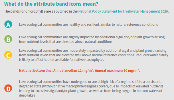
An example of the descriptions for an attribute state (chlorophyll a for Lakes) is given below:

