
A well is a hole that is drilled or dug into the ground to get or measure groundwater. The LAWA website contains basic information about the construction of many of the wells that regional councils use to monitor groundwater. The terms used on LAWA are described here.
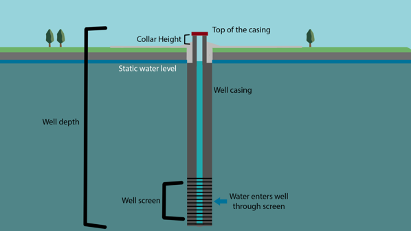
Figure 1: Well construction schematic
 Collar height
In most cases, a well has a casing or lining that keeps the hole open and prevents it from collapsing. In modern wells, the casing is typically a steel or PVC pipe. Older wells may have used materials like bricks or concrete. Some wells have no well casing because the geological material is strong enough to keep the hole from collapsing in on itself.
The well casing may extend above the ground surface. The height of the top of the casing above the ground surface is called the collar height. Some wells are finished below the ground surface in pits or toby boxes. Regional councils vary in how they record collar height for these wells, some using negative values and some using positive values.
The top of the well casing (the collar) is commonly used as a reference point for groundwater level measurements, but councils vary in what reference they use for measurements like well depth and screen interval. Some record these depths from the ground surface, while others record them from the top of the well casing or another fixed measuring point. LAWA does not currently distinguish between these different measuring points.
 Well depth
This is the depth to the bottom of the well, expressed in metres. LAWA does not currently specify whether the well depth is referenced to ground surface or another reference point.
 Well date drilled
The date that the well was drilled.
 Well diameter
This refers to the diameter of the well casing, expressed in millimetres. Modern drilled wells may have diameters ranging from 50 mm to 300 mm. Wells with PVC casing usually have diameters of 50 mm to 100 mm. Older dug wells may have diameters up to 1000 mm or more.
 Screen
In most wells, the casing is perforated or slotted over part of its length to allow water to enter the well while keeping the aquifer material in place outside the well. Modern wells typically have specially constructed screens for this purpose, like the one shown in Figure 2 below. Since the screen is where groundwater enters the well, groundwater level measurements and groundwater samples collected from the well represent groundwater conditions within the screened depth interval. LAWA lists the depths to the top and bottom of the screen in metres.
Some wells have more than one screened interval to tap multiple water-bearing depths. In this case, LAWA lists the depth to the top of the uppermost screen and the bottom of the lowermost screen.
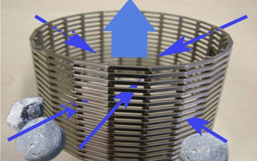
Figure 2. A typical well screen, showing how groundwater can enter the well through the screen mesh to be pumped up and out of the well, but aquifer material is held outside the well.
 Static water level /
  Static water level date
When a well is drilled, the driller will commonly measure the water level in the well after the well has been completed and allowed to rest for a while. This is recorded as the static water level and is generally measured near the date the well is drilled. Of course, groundwater levels change over time, so the recorded static water level of a well may be different to the level measured on any given day, but it does give a general indication of the water level in any case. Note also that while the static water level may be recorded from an uncertain measuring point, ongoing water level monitoring is generally tied to a fixed and well-defined measuring point like the top of the well casing.