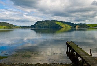
-
Lake size{{lakeDetails.size}}
-
Maximum depth{{lakeDetails.maxdepth}}
-
Catchment size{{lakeDetails.catchmentsize}}
-
Mixing pattern{{lakeDetails.mixingpattern}}
-
Geomorphic type{{lakeDetails.geomorphictype}}
This dashboard shows information on the data collected by the regional councils and unitary authorities for two indicators of lake water quality and ecological condition: TLI (Trophic Level Index) and LakeSPI (Lake Submerged Plant Indicators). Select an indicator to see the historical results.
-
Water Quality
Trophic Level Index (TLI)
{{rating() | uppercase}}
{{comment()}}The TLI score is an indicator of lake health and is determined from a suite of water quality measurements.
Show more information Hide informationTrophic Level Index (TLI) history for this lake
The TLI score for a lake is calculated from four water quality measurements – chlorophyll a, total nitrogen, total phosphorus and water clarity. If water clarity is unavailable, TLI is calculated using the other three water quality measurements. A higher score indicates poorer water quality.
Showing:toTLI history for Lake RotoehuYearWhat do the icons mean?
VERY GOODVery good water quality. Trophic Level Index of 0-2. Microtrophic lake conditions.GOODGood water quality. Trophic Level Index of 2-3. Oligotrophic lake conditions.FAIRAverage water quality. Trophic Level Index of 3-4. Mesotrophic lake conditions.POORPoor water quality. Trophic Level Index of 4-5. Eutrophic lake conditions.VERY POORVery poor water quality. Trophic Level Index of greater than 5. Supertrophic lake conditions.NO DATANo data available.TLI history for Lake Rotoehu data tableYear TLI Score Year TLI Score -
Ecological Conditions
Lake Submerged Plant Indicators (LakeSPI)
{{rating() | uppercase}}
{{comment()}}The LakeSPI status describes the ecological condition of the lake and is based on plants present.
Show more information Hide informationLakeSPI history for this lake
LakeSPI (Lake Submerged Plant Indicators) is a method of characterising the ecological condition of lakes based on the composition of native and invasive plants growing in them. A higher LakeSPI percentage result is associated with better ecological health:
LakeSPI N/A LakeSPI {{spiData.details.Value}}% The overall LakeSPI score is calculated using a Native Condition Index ('good' plants) and an Invasive Impact Index (introduced, non-native plants):
Native Condition N/A Native Condition {{spiData.details.NativeIndex}}% Invasive Impact N/A Invasive Impact {{spiData.details.InvasiveIndex}}% NA A higher Native Condition value indicates better ecological condition, but a higher Invasive Impact value indicates invasive plants are negatively impacting native plant communities.
View a factsheet on LakeSPI for more information on these indicators.- LakeSPI
- Native Condition
- Invasive Impact
Showing:toLakeSPI history for Lake RotoehuYearWhat is this graph showing me?
This graph is displaying the overall LakeSPI score over time. The results denote the ecological condition of the lake.
EXCELLENTExcellent ecological health. A LakeSPI score of 75-100%.HIGHHigh ecological health. A LakeSPI score of 50-75%.MODERATEModerate ecological health. A LakeSPI score of 20-50%.POORPoor ecological health. A LakeSPI score of 0-20%.NON-VEGNon-vegetated. A LakeSPI score of 0% (there are no plants present).NO DATANo data available.LakeSPI history for Lake Rotoehu data tableSample Date LakeSPI Status LakeSPI % Native Condition Index % Invasive Impact Index %  NIWA LakeSPI is licensed under a Creative Commons Attribution-Non Commercial 3.0 New Zealand License 2012.
Visit the NIWA LakeSPI website.
LakeSPI information has been provided by NIWA.

