Search all sites near me now
Search your favourite swimming spots

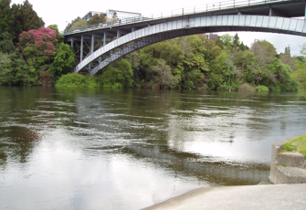
Waikato River at Hamilton Traffic Bridge

This site was monitored by NIWA up until 2016 and is one of the original National River Water Quality Network (NRWQN) sites dating back to 1989.    It is now a flow monitoring site run by Waikato Regional Council and recreational water quality information is collected at Wellington Street Beach upstream of Hamilton Traffic Bridge for 12 weeks over the summer period from the start of December to the end of February.

This site was monitored by NIWA as part of the NRWQN up until 2016. Samples were collected on the Left Bank at Hayes paddock near the Rowing club.  The monitoring site integrated effects of major pasture and horticulture development, hydro-electric schemes (8), geothermal fields, pulp and paper industry.

The catchment is predominantly forestry and dairying; changes include diary units increasing in size; from about 1998 a significant move from dairy farms to lifestyle blocks and residential development has occurred along the river banks. Forestry is on-going.

Live Data
Automatic 'live data' sampling

Some sites have telemetry monitoring systems in place that can provide up to the minute data. At this site the following live data measurements are available. Click on the data type for more information.

  • Flow

    • Last 7 days
    • Last 30 days
    • Last 12 months

    What is this graph showing me?

    The live flow estimate for this site.

    Live data has not been checked for accuracy before displaying. To give you an idea about how much water that is, 0.7 cumecs (m3/sec) would fill an Olympic swimming pool in an hour. A flow of 42 cumecs (m3/sec) would fill the same pool in a minute.

Disclaimer

The Environmental Data produced by this page should be used as a guide only. LAWA takes no responsibility for the accuracy of information presented, and accepts no liability for actions taken of others based on this information.
See this site